Share Augidog's profile
Augidog
Augidog's stats
- Review count7
- Helpfulness votes23
- First reviewAugust 30, 2008
- Last reviewMarch 1, 2017
- Featured reviews0
- Average rating3.4
- Review comment count2
- Helpfulness votes1
- First review commentNovember 3, 2010
- Last review commentJanuary 9, 2013
- Featured review comments0
Questions
- Question count0
- Helpfulness votes0
- First questionNone
- Last questionNone
- Featured questions0
- Answer count4
- Helpfulness votes2
- First answerDecember 12, 2009
- Last answerDecember 16, 2009
- Featured answers0
- Best answers0
Augidog's Reviews
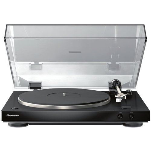
Enjoy rich, accurate sound with this Pioneer audiophile stereo turntable. It has a built-in phono equalizer, and its moving magnet stereo phono cartridge comes already mounted and ready for use. This Pioneer audiophile stereo turntable has a thick metal plate and a low center of gravity to keep your vinyl spinning with maximum stability and minimal feedback.
Posted by: Augidog
from NH
Others (in this price point and style). So, after much research on BBY, AMZN, CRTCHFLD, ETC. I bought this turntable. Why? Well, comparing the TEAC's ONKYO, MARANTZ, SONY, AUDIO TECHNICA, U-TURN, PRO-JECT, FLUANCE...etc. I found that all these companies do have mostly similar functions, motors, parts, options. And, where this Pioneer in now made (owned) by ONKYO/MARANTZ/DENON, this also made it easy. BUY a Reputable product owned by a decent high end company. Ok, so it wasn't the whole reason. But, here's another, auto on/off feature. Most of the HIGHER Cost (but not necessarily Hi-End) companies no longer or don't offer the "AUTO" feature. AUTO OFF, is MORE the feature you want. Most of the others don't have or offer it either. Unless you become so die-hard and create a listening room with $5000 equipment, this turntable as a play and walk away player (i.e. it shuts off by its self) can't be any better. Sure I just got it, set it up cleaned some records and started playing. Hey so far so GER---ATE! AND, you can upgrade cartridge, weight...etc. And So, for the money (which I won't share) it was worth every $200andsomething dollars! Thanks BestBuy. So, my only gripe really is inventory. This is an order product, which took at least a full 7business days. I didn't mind 'cuz it took that long for me to get my other pieces ordered and shipped. I will upgrade to a Red Ortofon cartridge, but not now, I want to put some miles on some records which with this stock cartridge sounds fine for my none $5000 listening equipment basement office. If you are jaunting into the LP world for listening and appreciating the cool factor of vinyl, this a great player to start and Mod (if you want)...Happy Listening!
My Best Buy number: 0067007073
I would recommend this to a friend!
Share this review:
+4points
4of 4voted this as helpful.
![Stone Temple Pilots [Deluxe Edition] [CD]](https://pisces.bbystatic.com/image2/BestBuy_US/images/products/9874/9874356_sa.jpg)
Customer Rating

2
Typical So-So STP
on May 23, 2010
Posted by: Augidog
from NH
STP is back at it again. After sampling this cd on amzn, I have to admit just another So-So Release by a band who's notorious for getting acclaim for making/writing "1" hit wonders. I would say off the studio 5 albums they have, there's only say 5 really good songs, and 30 iffy at best songs. I'm not sure I'd classify these guys as good. Like Nirvana, their 1st record=GREAT, everything else = GARBAGE! Why bother. For a lead singer to get tossed out of his original band to then get tossed out of what could have been his bread-n-butter to step back in and record this.....they should stick to what they know is best for them.....being broke-up! I rate this FAIR, cuz it is what it is, FAIR. It's all this band has ever been and ever will be. As for the guy who first wrote a review giving it 5 stars, dude check yer head, this isn't worth the plastic it's printed on. As for those who read this and beg to differ, that's fine. But I guarantee this isn't a CD you leave in yer player for weeks on end....unless you forget it's there, which will happen to many people.
What's great about it: Nothing
What's not so great: Noooothing!
No, I would not recommend this to a friend.
Share this review:
-7points
0of 7voted this as helpful.
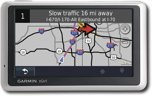
Use this convenient Garmin nüvi 1300T GPS receiver to navigate from here to there with preloaded maps of the lower 48 United States, Hawaii and Puerto Rico along with up to 5 million points of interest.
Posted by: Augidog
from NH
So I recently bought this NAV. and I do have to it was easy to get started by using it. Well the initial go was somewhat questionable, but once it picked up the Sat. signal it was all good. This thing picked up roads the other NAV's suppossively don't get (per other users of other various NAV, like a Magellan, and TOM TOM, I'm talking roads in the Catskills Mnts. of NY) So all in all i think it's a good little device. I think the company should give you at least 2 downloads, but I can't complain ( the big dig in Boston is done, so I really don't have to worry to much about screwed up construction projects sending off course. I'm pleased with this device, my only complaint is that Bestbuy put this on sale 35days after I bought it, where's my price adjustment? I give this a 4 because it's not the top of line model (no model ever is) so a 4 from me is good rating, that means I'd recmmend it or buy another one....I'm a picky s.o.b. so take my advice, or read my other reviews, they're out there on this site. Then go buy this if you don't have one, you can probably get one under $200 now
What's great about it: It hasn't done me wrong....yet
What's not so great: can't think of anything......yet
I would recommend this to a friend!
Durability

3
Ease of Use

4
Features
4
Share this review:
0points
0of 0voted this as helpful.
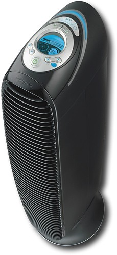
This HEPA air purifier reduces 99.9% of airborne particles, including dust, pollen, pet dander and smoke. The 12 cleaning channels ensure the air in your home or office remains clean.
Customer Rating

4
BESTBUY STOP BLOCKING MY REVIEWS!!!
on November 9, 2009
Posted by: Augidog
from NH
Ok, so this is my Second review, I gues BBY didn't like my first review which was a review of someone's review....i'll get to that. First, my review is: I bought 2, one for the lving area, and 1 for the bedroom. They seem to work, or so says the wife, but I still sneeze, so there's a problem somewhere with my allergies, that's another review for another time. As for these, sure I can't complain, other than i spent $400 for them, and I still sneeze :o) So, as I mentioned this is my 2nd try at this review. I critiqued someone from MN, as he/she said these were Super Great cuz they were made in MN by Honeywell, "helping the local economy" and that ionizing the air was super...although it makes your air 'sweet' or seemingly humid. First these are made by KAZ a Massechusettes company-NO LOCAL MINNESOTA ECONOMY HERE! And as far as ionizing the air and making NEW AIR (I think that's what she wrote) she abviously didn't do her homework. This features an ionizer, and a UV light. Now, when you ionize air you create ozone (charging the air with a position electron stealing 1 oxygen from the other oxygens floating around) now the UV, will break up 1 electron thus depleting the ozone by stealing or seperating it from the O3 which was created by the ionization (remember that sweet smell to the air, like a humid smell, yeah that) and this is what she called new AIR, whatever!. This really isn't the case when your working with the same AIR!!! In my first critique or review, I said buyers don't believe everyting you read, find out for yourself, and take these reviews with a grain of salt. After all they are just 'opinions'.....you know the deal! Thanks for reading, and go buy one even if you don't need one....HELP OUT THE MASSECHUSETTES ECONMOY, they Need it!!!
What's great about it: It hasn't Broke
What's not so great: Nothing
I would recommend this to a friend!
Quality
4
Features

5
Performance
4
Share this review:
-17points
17of 51voted this as helpful.
![Greatest Hits [Deluxe] [CD]](https://pisces.bbystatic.com/image2/BestBuy_US/images/products/9605/9605301_sa.jpg)
Customer Rating
2
Greeeeeeaaaaaaat, another GH's Release
on November 9, 2009
Posted by: Augidog
from NH
OK, OK Motley enough is enough! How many Greatest Hits Albums are you guys (NikkI) going to release? I think Mick is in the most dire straits as far as money is concerned but this isn't his genius. Ok, Lets let's review this and then I'll ramble about the cunning idea of Motley sitting around the soapbox thinking "Let's Release a Greatest Hits CD" derrrrrr..... Ok, so a review:
Songs 1-19 no matter what will always remain some of the FANS most favorite songs, not for me. Sure the are great, but there are so many other songs that are just as great or better. IF This band were really smart (since CD's don't cost anything nowadays to manufacture) they should release a disc of THEIR favorite Motley songs.....OR better yet, HOW ABOUT YOU FINISH, MUSIC TO CRASH YOUR CAR TOO!!! EH! Wouldn't that be an idea!!!! So for those who want to watch a 23min DVD of CrueFest Whooopie (go buy the actaul CrueFest DVD, It worth it) As for this I wouldn't waste yer money on it, IF YER A FAN, You know the deal.....will you make these guys a bit more richer by making yer collective contribution? I mean the last song remix MUST BE WORTH THE $10 bucks!!! Right? I recommend everyone read this and buyer beward, this will be Motley's Hmmm? let me count, um...1,2,3....or 4th Greatest Hits release? I guess after your first 2, it's hard tell where to stop! Come On this is silly! So next year the record another album, and release it the year after, go on tour, and release a 5th Greatest hits CD, with songs from the new albums added to the already GH's they've released...OMG! I can't wait, no wait, can some post the bands management contact info, maybe I should plant this seed......NO WAIT, I'm sure it's already in the making, just wait and see......
Songs 1-19 no matter what will always remain some of the FANS most favorite songs, not for me. Sure the are great, but there are so many other songs that are just as great or better. IF This band were really smart (since CD's don't cost anything nowadays to manufacture) they should release a disc of THEIR favorite Motley songs.....OR better yet, HOW ABOUT YOU FINISH, MUSIC TO CRASH YOUR CAR TOO!!! EH! Wouldn't that be an idea!!!! So for those who want to watch a 23min DVD of CrueFest Whooopie (go buy the actaul CrueFest DVD, It worth it) As for this I wouldn't waste yer money on it, IF YER A FAN, You know the deal.....will you make these guys a bit more richer by making yer collective contribution? I mean the last song remix MUST BE WORTH THE $10 bucks!!! Right? I recommend everyone read this and buyer beward, this will be Motley's Hmmm? let me count, um...1,2,3....or 4th Greatest Hits release? I guess after your first 2, it's hard tell where to stop! Come On this is silly! So next year the record another album, and release it the year after, go on tour, and release a 5th Greatest hits CD, with songs from the new albums added to the already GH's they've released...OMG! I can't wait, no wait, can some post the bands management contact info, maybe I should plant this seed......NO WAIT, I'm sure it's already in the making, just wait and see......
What's great about it: I donno, The Cover?
What's not so great: It's yet another Motley Greatest Hits CD! OMG!
I would recommend this to a friend!
Share this review:
-5points
0of 5voted this as helpful.
![Halestorm [CD]](https://pisces.bbystatic.com/image2/BestBuy_US/images/products/9277/9277748_sa.jpg)
Customer Rating
4
A Change in the Weather is coming....
on April 15, 2009
Posted by: Augidog
from NH
For a new band with a girl fronting the lead vocals, this band has the foundation to become bigger and better the Evanescense (who I think was a one hit wonder). I got an advance copy of this upcoming CD, and the lyrics seem solid. The music behind the lyrics is pretty sold too. You won't hear anything new as far as their rock sound. It's a pretty tight rock album. Let's hope they come like their name and wreak havack! If you like rock music and have money to spend buy this CD!
What's great about it: The Hot Chick fronting the Vocals!
What's not so great: n/a
I would recommend this to a friend!
Share this review:
+2points
2of 2voted this as helpful.
![Seven Days Live [CD] [PA]](https://pisces.bbystatic.com/image2/BestBuy_US/images/products/8942/8942175_sa.jpg)
Customer Rating

3
BUY THE DVD it's Better!!!
on August 30, 2008
Posted by: Augidog
from NH
Ok, so this would be great if: it was a 2 disc set. This isn't the same record label as Poison has for releases, so this might be why the full set list isn't included. If you like the classic Poison songs live sure this is good, but!!!...if you you're a true Poison fan....don't buy this CD, go buy the DVD 7 Days Live! You'll appreciate it that much more. This CD is more of a tickler....sorry.
What's great about it: It's Poison
What's not so great: It's not the full setlist
No, I would not recommend this to a friend.
Share this review:
0points
0of 0voted this as helpful.
Augidog's Review Comments
![Love Is in the Missile [CD] [PA]](https://pisces.bbystatic.com/image2/BestBuy_US/images/products/1160/1160016_sa.jpg)
Overall 5 out of 5
5 out of 5A great new band! every song on this CD rocks! a g
By hotrodrocker
A great new band! every song on this CD rocks! If you like hard rock, like Def Leppard only with a modern twist, you will love this CD!
Augidog
NH
NOT Like Def Leppard with a modern twist!
November 3, 2010
So this is the #2 review/comment to this band. Unlike the first person "Hotrod-whoever", this band has NO, NONE, ZEEEERO Modern Def Leppard qualities. They do have a sort of POP EVIL similarity-WHOM with they are currently touring with. That would be an interesting show if you like POP EVIL (I DO) saw a year ago, never heard of them, and bot the cd at the show....LOVE'EM. As for this band, sure there's some good tunes here, I like the album cover, but I wouldn't compare them to an ICONIC Rock Band (i.e Def Leppard). I'm on the fence as to buying this album...I guess I'll take a chance (I like the cover) ;o) and to see if the music grows on me, and whether I decide to update this comment. As for now, you might want to preview a couple songs; 1,2,6,& 10, those might be the strongest on the record.
0points
0of 0voted this comment as helpful.
Only at Best BuyThis portable CD player features an FM tuner with 10 station presets, so you can listen to your favorite stations on the go. The skip protection ensures your favorite tunes aren't interrupted.
Overall4 out of 5
4 out of 5Great Cd Player for the Money I spent
By CrayLeg10
from Grand Junction, CO
I like the features and everthing the Cd Player has. It cost 38 dollars and has mp3, and can play CD's and CD-r and u can also listen to the local Radio on it. It is multi-funtional and fun and easy to use.
Augidog
NH
4 stars??
January 9, 2013
What would have made this a 5star Cd player? I too, am looking to replace my protable cd player, and I've eyed this for weeks, just haven't pulled the trigger yet, but it seems to have great features.
+1point
1of 1voted this comment as helpful.
Augidog's Questions
Augidog has not submitted any questions.
Augidog's Answers
Movies & Music
Movies & Music
I want to learn how to read and speak Japanese, what books should I buy?
nothng written in Japanese.
14 years, 4 months ago
by
Augidog
NH
Brazilian Territories
Is it possible I buy Garmin or Tomtom there and download maps and information about Brazilian?
Because I want to use here Brazil.
Thanks
Trombini, Arnaldo
Because I want to use here Brazil.
Thanks
Trombini, Arnaldo
Check with Garmin, for those maps. If they have them they'll cost you some doe! I know they have maps of Europe.
14 years, 4 months ago
by
Augidog
NH
What is a waypoint?
Waypoints are, in simple terms are sources of longtitude and latitude (or altitude) that identify where one is. Almost like terrain marking (the most basic way to explain it is if you were hiking w/o GPS you'd make markings like; a big rock, dead tree, waterfall...etc). Nowadays it more abstrac like artificial beacons, and no real physical pairings, but more mathmatical related to numbers (latitude/longitude/altitude)
14 years, 4 months ago
by
Augidog
NH
What is location reporting?
When you compare units there is a section labeled location reporting what is this feature?
From my understanding, "location reporting' is like that of any GPS in that it knows where you are and it reports your location, right? It's a means of tracking to narrow down and pin-point you if ever lost, not just to tell you proxcimity of where you are.
14 years, 4 months ago
by
Augidog
NH